Driver
Aboriginal and Torres Strait Islander people’s owned land and water titles
Dashboard snapshot: The data below are the most recent at the time of preparing the July 2023 report. Please go to the dashboard to access the current data.
Measure 1
Proportion of all land that is Indigenous owned or controlled
Nationally as at June 2022, 16.1 per cent of Australia’s land area was owned or controlled by Aboriginal and Torres Strait Islander people. This is unchanged from the same time in the previous two years (June 2020 and 2021) (figure SE15a.1).
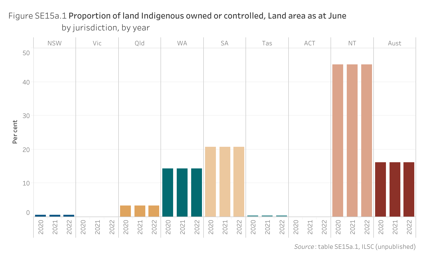
| Year | NSW | Vic | Qld | WA | SA | Tas | ACT | NT | Aust |
|---|---|---|---|---|---|---|---|---|---|
| 2020 | 0.6 | – | 3.3 | 14.3 | 20.7 | 0.4 | – | 45.1 | 16.1 |
| 2021 | 0.6 | – | 3.4 | 14.3 | 20.7 | 0.4 | – | 45.1 | 16.1 |
| 2022 | 0.6 | – | 3.4 | 14.3 | 20.7 | 0.4 | – | 45.1 | 16.1 |
– Nil or rounded to zero.
Measure 2
Proportion of water owned or controlled by Aboriginal and Torres Strait Islander people
Reporting for this measure is under development.
Indicator data specifications
Related outcome: | Aboriginal and Torres Strait Islander people maintain a distinctive cultural, spiritual, physical and economic relationship with their land and waters. |
|---|---|
Related target: | By 2030, a 15 per cent increase in:
|
Indicator: | Aboriginal and Torres Strait Islander people’s owned land and water titles. |
Measure: | Measure 1 is the proportion of all land that is Indigenous owned or controlled and is defined as: Numerator — land area owned or controlled by Aboriginal and Torres Strait Islander people at 30 June Denominator — total land area and is presented as a percentage. Measure 2 is the proportion of water owned or controlled by Aboriginal and Torres Strait Islander people. The specifications for this measure are under development. |
Indicator established: | National Agreement on Closing the Gap July 2020 |
Latest dashboard update for the indicator: | 8 March 2023 |
Indicator type: | Driver |
Interpretation of change: | For both measures, a high or increasing proportion is desirable. |
Data source(s): | Measure 1 Name (numerator): ILSC Indigenous held land dataset (2000). Frequency: Annual (revised NT and Australia Indigenous estate data for 2020 and 2021 in the March 2023 update) Documentation (links): https://www.ilsc.gov.au/ |
Data provider: | Measure 1 Provider name (numerator): Indigenous Land and Sea Corporation (ILSC) Provider area: Land and water ownership |
Baseline year: | Measure 1 2020 |
Latest reporting period: | Measure1 2022 |
Disaggregations: | Measure 1 State and Territory and Australia. |
Computation: | Measure 1 Numerator divided by Denominator multiplied by 100. Counting rules Measure 1 Numerator: Land area is in square kilometres (sq km). Land owned or controlled by Aboriginal and Torres Strait Islander people includes the following tenure types:
The different forms of land tenure report can overlap. Denominator: Total land area is in square kilometres (sq km) and is based on GeoScience Australia's published ‘Area of Australia - States and Territories’ data as calculated from GeoScience Australia's GEODATA Coast 100K 2004 product. Data for the ACT includes Jervis Bay. |
Data quality considerations: | Measure 1 In 2000, the ILSC developed a database of Indigenous owned land by querying land title registers using known Indigenous organisation names identified from state and federal Indigenous organisation registers. Other than information the ILSC has collected to support its legislated acquisition and management functions, this dataset has not been updated to reflect land boundary or tenure changes over the last 20 years. The data provided represents land parcels identified as legally owned by Indigenous Corporations (corporations registered with a state or federal register of Indigenous corporations, such as the Office of the Registrar of Indigenous Corporations (ORIC)) or as legally owned by Government and held exclusively for Aboriginal and Torres Strait Islander use. Data does not include land parcels owned by individual persons, nor does it include other legal Indigenous interests such as Native Title or regional Indigenous Protected Areas. The ILSC makes no warranties as to the currency or accuracy of land ownership information. |
Future reporting: | Measure 1 Additional developments required for future reporting:
|